Deforestation monitoring · Team and Consultant
Know when a plot is cleared. Before you ship from it.
Every plot in your supply chain, analysed by satellite every week. Scored, risk-assessed, and alerted only when it matters.
Plot 214 · Fazenda Boa VistaSoy · Pará, BR · 62.4 ha
Confirmed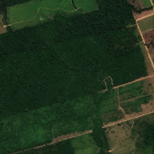
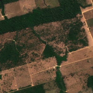
- Forest lost
- 38.1 ha
- Since cut-off
- Yes
- Supplier risk
- High
From satellite pixel to decision, automatically.
Analyse
Every plot, every week, from radar and optical satellite data. Clouds do not stop it.
Score
Each change gets a clear verdict, with the evidence behind it. Noise is set aside.
Assess risk
Verdicts flow into each supplier's and product's risk assessment, ready for the statement.
Alert
Only real deforestation reaches you, by email, in the app or to your own systems.
Alerts this week
| Plot | Supplier | Forest lost | Detected | Verdict |
|---|---|---|---|---|
| Plot 214 · Fazenda Boa Vista | Agro Norte Ltda | 38.1 ha | 22 Sep | Confirmed |
| Plot 88 · Taï Est | Coop Taï Nord | 1.4 ha | 29 Sep | Likely |
| Plot 1,102 · Soubré Ouest | Soubré Union | 0.3 ha | 30 Sep | Under watch |
Images: Pará, Brazil. Contains modified Copernicus Sentinel data 2022, 2024. Plot outline and figures are illustrative.
See your supply chain in EUDRplot.
A 30-minute walkthrough with your own supplier files.